![]()
What is a tel? 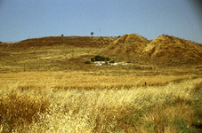
One way of knowing where to organize an archaeological dig
is to look for a tel . A tel is a mound or
small hill that has been built up over several centuries of occupation.
It is formed through the accumulation of remains of repeated building
activities and occupations, as towns and villages were built and
destroyed and then rebuilt, each new settlement placing its foundation on
top of what the earlier dwellers left behind. If you were to slice
through the tel, you would find a series of
layers or strata, each representing one period
in the site's history.
We find reference to this pattern of building and destruction already in the Hebrew Bible:
"the city shall be rebuilt on its
ruins..." Jer. 30:18
"...burn the town and all its spoil....it
shall remain a perpetual ruin, never to be rebuilt." Deut. 13:16
Tels are usually located at strategic geographical points. In ancient times, just as in rural
societies today, people want to live in areas with good access to water,
a favorable climate, good agricultural conditions, easy access to
trade routes, and with good defensive features. In sites with these conditions, settlements
would grow, and then be attacked, conquered, destroyed or abandoned.
New peoples would arrive and build their own cities on the site, using materials such as foundations,
building stones, fortifications and walls from the previous occupiers to construct their new cities. In this way a
tel is gradually built up over the centuries. Gezer, for example, has twenty-six identifiable strata spanning more than
3000 years.
![]()
How do Archaeologists dig a Site?
 When a tel is located, the first step in excavation is to map
out the site and establish a grid on the surface. This will help archaeologists
keep track of where they are finding materials and buildings. Depending on the
size of the tell and the goals of the excavator the tel might be divided into
areas., and each area divided further into squares
(usually 5 x 5 meters).
When a tel is located, the first step in excavation is to map
out the site and establish a grid on the surface. This will help archaeologists
keep track of where they are finding materials and buildings. Depending on the
size of the tell and the goals of the excavator the tel might be divided into
areas., and each area divided further into squares
(usually 5 x 5 meters).
Archaeologists excavate a tel in a systematic fashion--exposing each stratum one at time and carefully recording each find and its location in relation to the grid. When that stratum is fully mapped and catalog, it is destroyed to reveal the earlier stratum underneath. For example, a floor of a later occupation may be built upon the top level of the previous settlement. The bottom level is often bedrock and represents the oldest. Above it you may find many other levels of occupation, including destructions level, fallen stones, remains of cities with ancinet ancient houses and buildings. Working from the top down, the archaeologist will carefully remove one stratum at a time, each new stratum revealing a new set of features.
When archaeologists excavate a site, they often find material from an earlier period being used by a later settlement. This is what in archaeology is called "secondary use" of an artifact.
In order to keep track of finds from parts of the tel that will be
destroyed to get at lower levels, a 1 meter area between each square, a balk
is left unexcavated. 
The face of
the balk is called a section and reflects the
stratigraphy of the area and so is one of the most crucial tools for archaeological interpretation.
The section is measured precisely, both horizontally and vertically,
and it is carefully photographed or drawn to show all significant features,
such as changes in dirt texture and color. The excavator will then usually remove the balk, leaving
only the section drawing as a record of what was found. In addition,
the area and the squares will be drawn to show the surface from a horizontal
perspective.
Everything excavated is carefully recorded and measured. Each layer, find, feature, and artifact is measured, recorded and then entered into a database which will be used later to assist in analysis. Several times a day, levels, or vertical measurements, will be taken. Levels are taken by means of a transit view and measured leveling rod. The picture below shows an archaeologist taking and recording levels.

![]()
![]()
Bibliography
Ben-Tor, Ammon. The Archaeology of
Ancient Israel. Yale: Yale University Press, 1992.
Fritz, Volkmar. An Introduction to Biblical Archaeology. Sheffield, England: JSOT Press, 1996.
Lance, H. Darrell. The Old Testament and the Archaeologist. Philadelphia: Fortress Press, 1981.